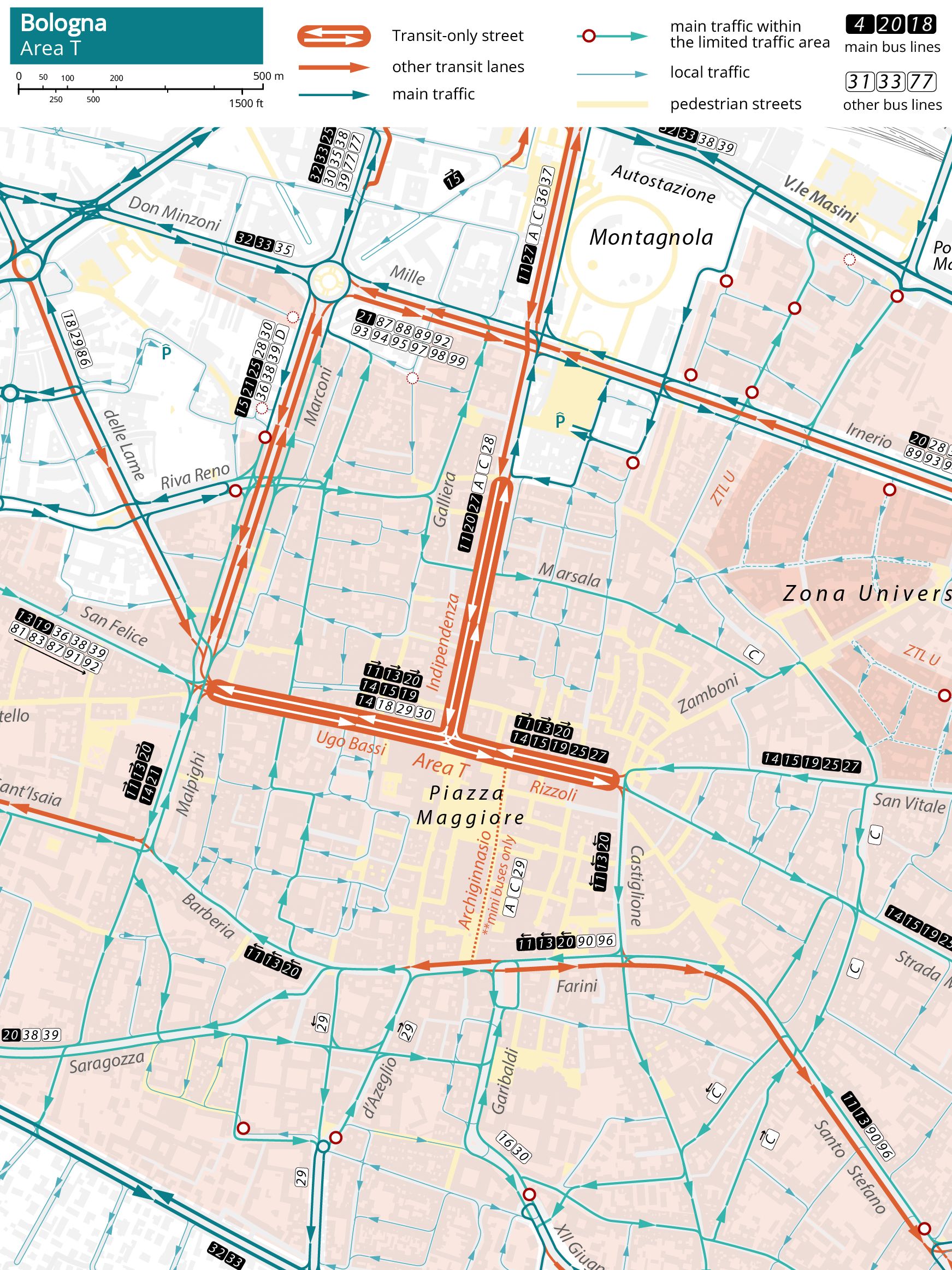
Bologna: Area T
Tools: a1f1-f2z1l4
Strategies: divert-through-trafficreduce-background-trafficcurb-frictionhigh-capacity
The Area T transit-only streets (A1) scheme reserves the main thoroughfares of Bologna’s city core (via Bassi, via Rizzoli and via dell’Indipendenza) to transit vehicles at all times. Area T is also open to bikes, motorcycles, taxis, and a limited number of private motor vehicles through a permitting system. Deliveries are allowed on lateral streets. Area T streets carry heavy bus traffic, with up to 1,000 buses per day in each direction in the most-used segment, and more than 100 buses during the morning peak hour. Many lateral streets have been pedestrianized or dead-ended, reducing the number of signal-controlled intersections to only three, with the few remaining crossings controlled with lateral-street-only yields.Stops are organized in a skip-stop configuration, with platforms extending for the length of two or even more articulated buses. In Via Ugo Bassi and Via Rizzoli, the stops are located where the roadway is large enough to accommodate overtaking transit vehicles.
Already envisioned in the seminal 1972 traffic plan, the scheme was implemented over time through increasingly restrictive access regulations, culminating in its current configuration during the first half of the 1990s. Area T is part of a broader, comprehensive rearrangement of circulation patterns at the city and neighbourhood levels, complemented by the establishment of a Limited Traffic Area (Z1) (ZTL - Zona a Traffico Limitato) in most of the city centre. Main vehicular patterns around the pedestrian and transit-only core are arranged to avoid through traffic in the inner core of the city center, with local accessibility organized in pockets of looping circulation patterns that send flows back to clearly identified through routes. Since 2011, Area T has been pedestrianized on weekends and public holidays, and buses have been diverted to alternative routes. As part of the tramway works, via dell’Indipendenza will be permanently pedestrianized and reserved for trams only.
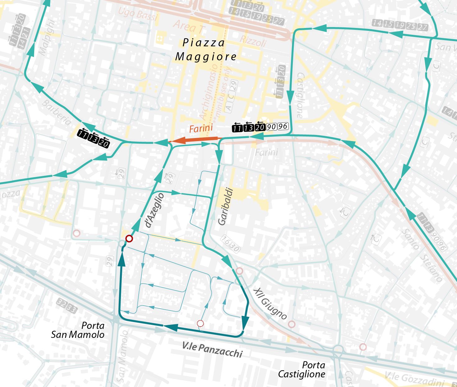
The strategy to divert through traffic is replicated along other key corridors of the city center, for example, on a key westbound transit corridor used by three trunk routes at the southern edge of the pedestrian core. A short segment of contraflow transit lane (F1) is deployed on Via Farini between Piazza Cavour and Via d’Azeglio. Together with the configuration of one-way circulation patterns in the area between Via Garibaldi, Viale XII Giugno, Viale Panzacchi and Via d’Azeglio, it obliges all westbound through traffic south of the pedestrian and transit-only core to reach back to the ring boulevard. This drastic deviation of through traffic has proven contentious and was temporarily suspended during the second half of the 2010s, but was eventually reactivated in 2024.